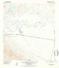
1952 Map of Tanacross B-5
USGS Topo · Published 1952About this map
The Tanacross settlement and the adjacent Tanacross Airfield serve as the focal point of this 1952 survey, situated at a strategic bend of the Tanana River. This region represents a critical junction in mid-century Alaskan transportation, where the Alaska Highway and Glenn Highway converge. A major Pipe Line runs parallel to the roadway, highlighting the infrastructure of the post-war era. To the north, the landscape is defined by the winding Little Tanana Slough and large water bodies including Lake Mansfield and Fish Lake. The Eagle Trail is visible striking southeast across the terrain toward the foothills. In the south, the massive peaks of the Alaska Range dominate the horizon, marked by survey points such as VABM Lookout. The map provides a look at the intersection of river navigation and emerging overland routes in the interior.
Find a feature on this map
26 named features on this map. Tap any name to fly to it.
Don’t see what you’re looking for? This feature index may not catch every label — zoom into the map to look around manually.
Map Details
Editions of this 1952 Tanacross B-5 Map
2 editions found

Other maps of this area

1948 · Tanacross B-5
USGS Topo · 1:63,360

1948 · Tanacross A-6
USGS Topo · 1:63,360

1948 · Tanacross A-4
USGS Topo · 1:63,360

1948 · Tanacross A-5
USGS Topo · 1:63,360

1949 · Tanacross
USGS Topo · 1:250,000

1949 · Tanacross B-4
USGS Topo · 1:63,360

1949 · Tanacross A-5
USGS Topo · 1:63,360

1949 · Tanacross B-6
USGS Topo · 1:63,360

1950 · Tanacross
USGS Topo · 1:250,000

1951 · Tanacross B-6
USGS Topo · 1:63,360