
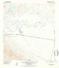
1952 Map of Tanacross B-5
USGS Topo · Published 1952About this map
The Tanana River cuts through the center of this Alaskan wilderness, forming a complex network of braids and the Tanana Slough as it flows between the high peaks of the Alaska Range to the south and the lake country to the north. At the junction of the river and the Alaska Highway, the settlement of Tanacross serves as a primary hub, supported by the Tanacross Airfield and a prominent beacon. The presence of the Pipe Line running parallel to the highway highlights the importance of the era's logistical infrastructure in the interior.
Find a feature on this map
31 named features on this map. Tap any name to fly to it.
Don’t see what you’re looking for? This feature index may not catch every label — zoom into the map to look around manually.
Map Details
Editions of this 1952 Tanacross B-5 Map
2 editions found
Other maps of this area

1948 · Tanacross B-5
USGS Topo · 1:63,360

1948 · Tanacross A-6
USGS Topo · 1:63,360

1948 · Tanacross A-4
USGS Topo · 1:63,360

1948 · Tanacross A-5
USGS Topo · 1:63,360

1949 · Tanacross
USGS Topo · 1:250,000

1949 · Tanacross B-4
USGS Topo · 1:63,360

1949 · Tanacross A-5
USGS Topo · 1:63,360

1949 · Tanacross B-6
USGS Topo · 1:63,360

1950 · Tanacross
USGS Topo · 1:250,000

1951 · Tanacross B-6
USGS Topo · 1:63,360