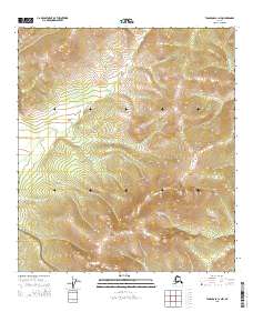
2015 Map of Tanacross C-1 NW
USGS Topo · Published 2015About this map
E Fork Dennison Fork flows through the northern reaches of this interior Alaskan territory, carving a drainage pattern through the high-elevation landscape of Southeast Fairbanks. This 2015 U.S. Geological Survey representation documents a region defined by its hydrography rather than human infrastructure, as seen in the prominent flow of McCord Cr and McElfish Cr toward the eastern boundary. The map serves as a detailed study of land management and township divisions, including t23n r21e and t22n r20e, illustrating the systematic grid applied even to such isolated reaches of the Tanacross region. The absence of roads or named settlements underscores the wild character of the terrain during this era, where the only landmarks for navigation are the natural watercourses and the relief of the peaks.
Find a feature on this map
9 named features on this map. Tap any name to fly to it.
Don’t see what you’re looking for? This feature index may not catch every label — zoom into the map to look around manually.
Map Details
Editions of this 2015 Tanacross C-1 NW Map
This is the sole edition of this map. No revisions or reprints were ever made.
Other maps of this area

1949 · Tanacross
USGS Topo · 1:250,000

1950 · Tanacross
USGS Topo · 1:250,000

1956 · Tanacross C-1
USGS Topo · 1:63,360

1956 · Tanacross D-2
USGS Topo · 1:63,360

1956 · Tanacross C-2
USGS Topo · 1:63,360

1956 · Tanacross D-1
USGS Topo · 1:63,360

1956 · Tanacross
USGS Topo · 1:250,000

1964 · Tanacross
USGS Topo · 1:250,000
2013 · Tanacross C-2 SE
USGS Topo · 1:25,000
2013 · Tanacross D-2 SE
USGS Topo · 1:25,000