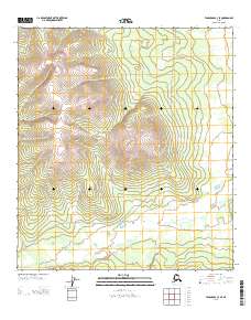
2013 Map of Tanacross C-3 SE
USGS Topo · Published 2013About this map
Dennison Fork snakes through the southern half of this Tanacross quadrangle, carving a winding path through a landscape defined by significant elevation changes. The waterway serves as a primary geographic anchor for this remote section of the Alaska interior, where the terrain rises steeply away from the river valley. A series of routes marked as Winter Trl cross the territory, illustrating the seasonal nature of travel and access in this region. These trails follow the contours of the land and the valley floor, connecting different segments of the watershed. The map clearly delineates the township and range lines, such as the boundary between T 21 N and T 20 N, which provide a formal grid over the seemingly untamed Alaskan wilderness during the early 21st century.
Find a feature on this map
5 named features on this map. Tap any name to fly to it.
Don’t see what you’re looking for? This feature index may not catch every label — zoom into the map to look around manually.
Map Details
Editions of this 2013 Tanacross C-3 SE Map
This is the sole edition of this map. No revisions or reprints were ever made.
Other maps of this area

1948 · Tanacross B-3
USGS Topo · 1:63,360

1949 · Tanacross
USGS Topo · 1:250,000

1949 · Tanacross B-3
USGS Topo · 1:63,360

1950 · Tanacross
USGS Topo · 1:250,000

1952 · Tanacross B-3
USGS Topo · 1:63,360

1956 · Tanacross C-3
USGS Topo · 1:63,360

1956 · Tanacross C-2
USGS Topo · 1:63,360
1956 · Tanacross B-2
USGS Topo · 1:63,360

1956 · Tanacross
USGS Topo · 1:250,000

1964 · Tanacross
USGS Topo · 1:250,000