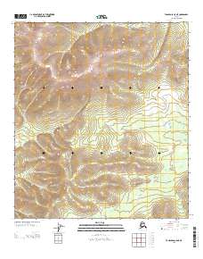
2013 Map of Tanacross C-5 NE
USGS Topo · Published 2013About this map
Mansfield Cr flows through this interior landscape, marking a prominent drainage system in the Tanacross region of Southeast Fairbanks. The topography is dominated by the watershed of the W Fork Dennison Fork, which occupies the southeastern portions of the map. This 2013 U.S. Geological Survey topographic study illustrates the intricate relief of the high country between these two water systems, providing a detailed look at the hydrology and land elevation patterns before contemporary shifts in the subarctic environment. The map details the cadastral grid intersections of townships T 23 N through T 21 N, anchoring these natural features within the established public land survey system. It serves as a precise record of a largely undeveloped wilderness area where the terrain itself is the primary landmark.
Find a feature on this map
5 named features on this map. Tap any name to fly to it.
Don’t see what you’re looking for? This feature index may not catch every label — zoom into the map to look around manually.
Map Details
Editions of this 2013 Tanacross C-5 NE Map
This is the sole edition of this map. No revisions or reprints were ever made.
Other maps of this area

1949 · Tanacross
USGS Topo · 1:250,000

1950 · Tanacross
USGS Topo · 1:250,000

1956 · Tanacross D-4
USGS Topo · 1:63,360
1956 · Tanacross C-5
USGS Topo · 1:63,360
1956 · Tanacross D-5
USGS Topo · 1:63,360
1956 · Tanacross C-4
USGS Topo · 1:63,360

1956 · Tanacross
USGS Topo · 1:250,000

1964 · Tanacross
USGS Topo · 1:250,000
2013 · Tanacross C-4 NW
USGS Topo · 1:25,000
2013 · Tanacross D-4 SW
USGS Topo · 1:25,000