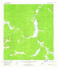
1956 Map of Tanacross C-4
USGS Topo · Published 1964About this map
West Fork Dennison Fork winds through this interior Alaskan wilderness, as documented during a mid-1950s Geological Survey aerial survey. The landscape is defined by its extensive drainage systems, where high-altitude ridges descend into broad, swampy valleys marked by numerous small ponds and thaw lakes. This specific quadrangle captures a moment before modern infrastructure reached this part of the Copper River Meridian, showing the land as it existed when only the Bureau of Land Management had predetermined unsurveyed land lines. The terrain is a complex network of unnamed peaks and ridges, where the water patterns of the West Fork Dennison Fork provide the primary geographical orientation for the region.
Find a feature on this map
1 named feature on this map. Tap any name to fly to it.
Don’t see what you’re looking for? This feature index may not catch every label — zoom into the map to look around manually.
Map Details
Editions of this 1956 Tanacross C-4 Map
2 editions found
Other maps of this area

1948 · Tanacross B-5
USGS Topo · 1:63,360

1948 · Tanacross B-3
USGS Topo · 1:63,360

1949 · Tanacross
USGS Topo · 1:250,000

1949 · Tanacross B-4
USGS Topo · 1:63,360

1949 · Tanacross B-3
USGS Topo · 1:63,360

1950 · Tanacross
USGS Topo · 1:250,000

1951 · Tanacross B-4
USGS Topo · 1:63,360

1952 · Tanacross B-5
USGS Topo · 1:63,360

1952 · Tanacross B-3
USGS Topo · 1:63,360

1956 · Tanacross D-3
USGS Topo · 1:63,360