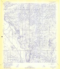
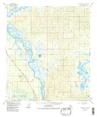
1955 Map of Tanacross C-6
USGS Topo · Published 1963About this map
The Tanana River and its confluence with the Robertson River define this mid-1950s interior Alaskan landscape. This survey documents a critical corridor of northern transport and infrastructure, following the path of the Alaska Highway as it cuts across the southern portion of the quadrangle. The map captures the industrial character of the territory during this era, explicitly noting the route of the Aboveground Alaska Pipeline alongside the river's eastern banks. High-elevation survey stations such as VABM 3461 (Fridell) and VABM 3735 (Tower) overlook a terrain defined by complex water systems, including Bluff Rapids and the winding courses of Billy Creek and Chief Creek. These features illustrate the intersection of traditional river-based movement and the post-war expansion of essential land-based supply routes in the subarctic.
Find a feature on this map
12 named features on this map. Tap any name to fly to it.
Don’t see what you’re looking for? This feature index may not catch every label — zoom into the map to look around manually.
Map Details
Editions of this 1955 Tanacross C-6 Map
5 editions found
Other maps of this area

1948 · Tanacross B-5
USGS Topo · 1:63,360

1949 · Tanacross
USGS Topo · 1:250,000

1949 · Tanacross B-6
USGS Topo · 1:63,360

1950 · Tanacross
USGS Topo · 1:250,000

1950 · Mount Hayes
USGS Topo · 1:250,000

1951 · Mount Hayes
USGS Topo · 1:250,000

1951 · Tanacross B-6
USGS Topo · 1:63,360

1952 · Tanacross B-5
USGS Topo · 1:63,360

1954 · Mount Hayes B-1
USGS Topo · 1:63,360

1954 · Tanacross C-6
USGS Topo · 1:63,360