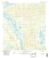
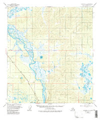
1955 Map of Tanacross C-6
USGS Topo · Published 1982About this map
The Tanana River dominates this interior landscape, weaving a complex braided channel through a wide valley of muskeg and wetlands. Surveyed in the mid-1950s, the map highlights the critical transportation corridor of the Alaska Highway as it parallels the river's southern bank. This vital artery is joined by an above-ground Pipeline, reflecting the postwar infrastructure developments in the Alaska interior. The confluence of the Robertson River and the Tanana serves as a focal point for the region's hydrology, where silt-laden glacial waters meet the broader river system.
Find a feature on this map
26 named features on this map. Tap any name to fly to it.
Don’t see what you’re looking for? This feature index may not catch every label — zoom into the map to look around manually.
Map Details
Editions of this 1955 Tanacross C-6 Map
5 editions found
Other maps of this area

1948 · Tanacross B-5
USGS Topo · 1:63,360

1949 · Tanacross
USGS Topo · 1:250,000

1949 · Tanacross B-6
USGS Topo · 1:63,360

1950 · Tanacross
USGS Topo · 1:250,000

1950 · Mount Hayes
USGS Topo · 1:250,000

1951 · Mount Hayes
USGS Topo · 1:250,000

1951 · Tanacross B-6
USGS Topo · 1:63,360

1952 · Tanacross B-5
USGS Topo · 1:63,360

1954 · Mount Hayes B-1
USGS Topo · 1:63,360

1954 · Tanacross C-6
USGS Topo · 1:63,360