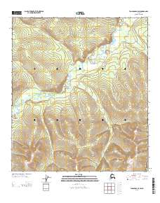
2013 Map of Tanacross D-3 SW
USGS Topo · Published 2013About this map
W Fork Dennison Fork winds through this interior Alaskan landscape, defining the drainage patterns of a territory largely untouched by permanent settlement. The terrain is characterized by significant elevation changes, notably at Balls Pass, which serves as a natural corridor through the high ground. In the early 21st century, the presence of the Taylor Hwy in the southeastern corner remains the primary terrestrial link to the outside world, cutting through a wilderness dominated by seasonal waterways like Logging Cabin Cr. The map captures the intersection of Range 15 East and Range 16 East, illustrating the vast survey grids that organize this expansive terrain into manageable townships. This area represents the enduring character of Southeast Fairbanks, where the landscape is shaped more by hydrology and natural passes than by human development.
Find a feature on this map
6 named features on this map. Tap any name to fly to it.
Don’t see what you’re looking for? This feature index may not catch every label — zoom into the map to look around manually.
Map Details
Editions of this 2013 Tanacross D-3 SW Map
This is the sole edition of this map. No revisions or reprints were ever made.
Other maps of this area

1949 · Tanacross
USGS Topo · 1:250,000

1950 · Tanacross
USGS Topo · 1:250,000

1956 · Tanacross D-3
USGS Topo · 1:63,360

1956 · Tanacross C-3
USGS Topo · 1:63,360

1956 · Tanacross D-4
USGS Topo · 1:63,360
1956 · Tanacross C-4
USGS Topo · 1:63,360

1956 · Tanacross
USGS Topo · 1:250,000

1964 · Tanacross
USGS Topo · 1:250,000
2013 · Tanacross C-4 NE
USGS Topo · 1:25,000
2013 · Tanacross D-4 SE
USGS Topo · 1:25,000