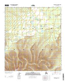
2013 Map of Tanacross D-5 SE
USGS Topo · Published 2013About this map
Mosquito Fork meanders through the northern reaches of this Alaskan interior landscape, where the drainage patterns of the upper Tanana Valley define the terrain. The map captures a largely untouched wilderness area dominated by the winding course of Wolf Cr, which cuts across the central and southern sections. This 2013 survey provides a detailed topographic record of the shifting elevations between the river valley and the rising uplands. The absence of road infrastructure or named settlements highlights the area's character as a remote corridor for regional waterways. Surveyors from the U. S. Geological Survey documented the public land survey system boundaries, including the intersection of T 24 N and R 12 E, providing a precise spatial framework for this portion of the Southeast Fairbanks region.
Find a feature on this map
4 named features on this map. Tap any name to fly to it.
Don’t see what you’re looking for? This feature index may not catch every label — zoom into the map to look around manually.
Map Details
Editions of this 2013 Tanacross D-5 SE Map
This is the sole edition of this map. No revisions or reprints were ever made.
Other maps of this area

1949 · Tanacross
USGS Topo · 1:250,000

1950 · Tanacross
USGS Topo · 1:250,000

1956 · Tanacross D-4
USGS Topo · 1:63,360
1956 · Tanacross C-5
USGS Topo · 1:63,360
1956 · Tanacross D-5
USGS Topo · 1:63,360
1956 · Tanacross C-4
USGS Topo · 1:63,360

1956 · Tanacross
USGS Topo · 1:250,000

1964 · Tanacross
USGS Topo · 1:250,000
2013 · Tanacross C-4 NW
USGS Topo · 1:25,000
2013 · Tanacross D-5 NE
USGS Topo · 1:25,000