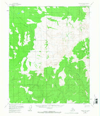
1956 Map of Tanana B-4
USGS Topo · Published 1968About this map
The Tanana-Allakaket Winter Trail cuts a diagonal path across this 1950s landscape, serving as a vital overland corridor through the interior before the expansion of more permanent infrastructure. This topographic survey, based on aerial photography from 1952 and 1953, centers on the high ground near Vabm 3484 Schut. The hydrology is defined by a series of significant drainages, including Ptarmigan Creek and Morelock Creek in the northeast, while Reindeer Creek and Mission Creek flow through the western and southern reaches. The arrangement of these watercourses and the presence of the winter trail reveal the seasonal nature of travel and subsistence in the Yukon-Koyukuk region during the mid-20th century, where geography dictated the movement of people and supplies across the unmapped and unsurveyed interior.
Find a feature on this map
9 named features on this map. Tap any name to fly to it.
Don’t see what you’re looking for? This feature index may not catch every label — zoom into the map to look around manually.
Map Details
Editions of this 1956 Tanana B-4 Map
2 editions found

Other maps of this area

1951 · Tanana
USGS Topo · 1:250,000

1952 · Tanana A-3
USGS Topo · 1:63,360

1952 · Tanana A-4
USGS Topo · 1:63,360

1952 · Tanana A-5
USGS Topo · 1:63,360

1953 · Tanana A-3
USGS Topo · 1:63,360

1953 · Tanana A-5
USGS Topo · 1:63,360

1956 · Tanana B-5
USGS Topo · 1:63,360

1956 · Tanana C-3
USGS Topo · 1:63,360

1956 · Tanana B-3
USGS Topo · 1:63,360

1956 · Tanana C-5
USGS Topo · 1:63,360