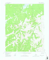
1956 Map of Tanana D-5
USGS Topo · Published 1960About this map
The Ray Mountains dominate this 1956 topographical survey, exhibiting a landscape defined by dramatic elevation changes and a radial drainage pattern. Located in the Yukon-Koyukuk region of Alaska, the area is characterized by high alpine ridges and deep valleys carved by seasonal and perennial waterways. This map, based on aerial photography from the early 1950s, documents a wilderness devoid of roads or permanent settlements during this era. Major water features including Hotonada Creek, Nethkahati Creek, and the North Fork Dagislakhna Creek originate in these high elevations, providing a clear picture of the hydrological flow toward the Tanana and Yukon basins. For researchers, the presence of landmarks like VABM Fork indicates established surveying points used by the U.S. Geological Survey to map this interior Alaskan terrain during a period of extensive aerial photogrammetric expansion.
Find a feature on this map
5 named features on this map. Tap any name to fly to it.
Don’t see what you’re looking for? This feature index may not catch every label — zoom into the map to look around manually.
Map Details
Editions of this 1956 Tanana D-5 Map
2 editions found
Other maps of this area

1951 · Bettles
USGS Topo · 1:250,000

1951 · Tanana
USGS Topo · 1:250,000

1956 · Bettles
USGS Topo · 1:250,000

1956 · Tanana D-4
USGS Topo · 1:63,360

1956 · Tanana C-6
USGS Topo · 1:63,360

1956 · Tanana D-6
USGS Topo · 1:63,360

1956 · Tanana C-5
USGS Topo · 1:63,360
1956 · Tanana D-5
USGS Topo · 1:63,360

1956 · Tanana C-4
USGS Topo · 1:63,360

1956 · Tanana
USGS Topo · 1:250,000