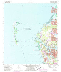
1973 Map of Tarpon Springs
USGS Topo · Published 1988About this map
Anclote Key State Preserve and the barrier islands of the Anclote Keys shield the mainland from the Gulf of Mexico, framing the quiet waters of Anclote Anchorage. Along the coast, the transition from maritime wilderness to suburban development is evident in the mid-1970s. Residential fingers stretch into the salt marshes at Gulf Harbors and Beacon Square, while the traditional core of Tarpon Springs remains centered around the intricate waterways of Whitcomb Bayou and Spring Bayou.
Find a feature on this map
72 named features on this map. Tap any name to fly to it.
Don’t see what you’re looking for? This feature index may not catch every label — zoom into the map to look around manually.
Map Details
Editions of this 1973 Tarpon Springs Map
4 editions found
Other maps of this area

1943 · Dunedin
USGS Topo · 1:31,680

1943 · Tarpon Springs
USGS Topo · 1:31,680

1943 · Elfers
USGS Topo · 1:24,000

1943 · Oldsmar
USGS Topo · 1:24,000

1944 · Elfers
USGS Topo · 1:31,680

1944 · Oldsmar
USGS Topo · 1:31,680

1948 · Elfers
USGS Topo · 1:25,000

1954 · Port Richey
USGS Topo · 1:24,000

1955 · Plant City
USGS Topo · 1:250,000

1958 · Plant City
USGS Topo · 1:250,000