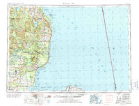
1954 Map of Tawas City
USGS Topo · Published 1976About this map
The Au Sable River basin serves as a central hub of activity on this survey, where a series of hydroelectric developments including Loud Dam, Five Channels Dam, Cooke Dam, and Foote Dam harness the river's descent toward Oscoda. Along the Lake Huron coastline, the Detroit and Mackinac RR connects industrial and maritime sites like the gypsum operations at Alabaster with coastal settlements from Tawas City to Alpena. Navigation is a primary theme, with the map recording numerous lighthouses and the Tawas Point Coast Guard Station, alongside more ephemeral markers like submerged net stakes in Saginaw Bay. The interior is largely defined by the Huron National Forest and the Wurtsmith AFB, while the Michigan Islands N W R protects the offshore environments of Thunder Bay.
Find a feature on this map
78 named features on this map. Tap any name to fly to it.
Don’t see what you’re looking for? This feature index may not catch every label — zoom into the map to look around manually.
Map Details
Editions of this 1954 Tawas City Map
4 editions found
Other maps of this area

1954 · Traverse City
USGS Topo · 1:250,000

1954 · Midland
USGS Topo · 1:250,000

1954 · Flint
USGS Topo · 1:250,000

1954 · Tawas City
USGS Topo · 1:250,000

1954 · Alpena
USGS Topo · 1:250,000

1955 · Atlanta
USGS Topo · 1:62,500

1955 · Comins
USGS Topo · 1:62,500

1955 · Hillman
USGS Topo · 1:62,500

1955 · Cheboygan
USGS Topo · 1:250,000

1957 · Alpena
USGS Topo · 1:250,000