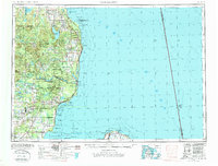
1954 Map of Tawas City
USGS Topo · Published 1987About this map
Lake Huron and its complex shoreline dominate the eastern half of this mid-century landscape, which balances the growing military presence at Wurtsmith AFB with the wild expanse of the Huron National Forest. Along the coast, the Detroit and Mackinac railroad corridor links maritime settlements from Alpena down through Oscoda and Tawas City. A significant inland feature is the sprawling Fletcher Pond, surrounded by specialized landmarks like Chin Whisker Hill and the remote communities of Barton City and Glennie. The survey highlights the maritime infrastructure of the era, including a Coast Guard Station at Tawas Point and various submerged net stakes and fish traps within Tawas Bay and Saginaw Bay. Further south, industry is marked by a Strip mine and Quarry near Alabaster, showing the region's extraction history alongside the protected environments of the Michigan Islands N W R.
Find a feature on this map
112 named features on this map. Tap any name to fly to it.
Don’t see what you’re looking for? This feature index may not catch every label — zoom into the map to look around manually.
Map Details
Editions of this 1954 Tawas City Map
4 editions found
Other maps of this area

1954 · Traverse City
USGS Topo · 1:250,000

1954 · Midland
USGS Topo · 1:250,000

1954 · Flint
USGS Topo · 1:250,000

1954 · Tawas City
USGS Topo · 1:250,000

1954 · Alpena
USGS Topo · 1:250,000

1955 · Atlanta
USGS Topo · 1:62,500

1955 · Comins
USGS Topo · 1:62,500

1955 · Hillman
USGS Topo · 1:62,500

1955 · Cheboygan
USGS Topo · 1:250,000

1957 · Alpena
USGS Topo · 1:250,000