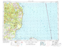
1954 Map of Tawas City
USGS Topo · Published 1976About this map
The Au Sable River corridor serves as the industrial and hydroelectric spine of this mid-century Northeast Michigan landscape. Series of power structures, including Loud Dam, Five Channels Dam, and Foote Dam, illustrate the intensive utility development of the river as it flows toward Au Sable and Lake Huron. The presence of the Wurtsmith Air Force Range and Wurtsmith AFB near Oscoda highlights the region's strategic military importance during the Cold War era.
Find a feature on this map
113 named features on this map. Tap any name to fly to it.
Don’t see what you’re looking for? This feature index may not catch every label — zoom into the map to look around manually.
Map Details
Editions of this 1954 Tawas City Map
4 editions found
Other maps of this area

1954 · Traverse City
USGS Topo · 1:250,000

1954 · Midland
USGS Topo · 1:250,000

1954 · Flint
USGS Topo · 1:250,000

1954 · Tawas City
USGS Topo · 1:250,000

1954 · Alpena
USGS Topo · 1:250,000

1955 · Atlanta
USGS Topo · 1:62,500

1955 · Comins
USGS Topo · 1:62,500

1955 · Hillman
USGS Topo · 1:62,500

1955 · Cheboygan
USGS Topo · 1:250,000

1957 · Alpena
USGS Topo · 1:250,000