
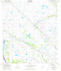
1953 Map of Taylor Creek SW
USGS Topo · Published 1954About this map
Yates Marsh dominates the central landscape of this Florida interior, a complex network of wetlands and sloughs defined by the seasonal movement of water. In the early 1950s, the Kissimmee River formed the western boundary of the quadrangle at Platt Bluff, shortly before the massive drainage projects of the mid-20th century permanently altered the river's meandering course. The Seaboard Air Line railroad cuts a straight path southeast through the marshland, providing a critical transport link for remote outposts like Mildred and the Dixie Ranch.
Find a feature on this map
18 named features on this map. Tap any name to fly to it.
Don’t see what you’re looking for? This feature index may not catch every label — zoom into the map to look around manually.
Map Details
Editions of this 1953 Taylor Creek SW Map
2 editions found
Other maps of this area

1952 · Okeechobee NW
USGS Topo · 1:24,000

1952 · Okeechobee
USGS Topo · 1:24,000

1953 · Taylor Creek NW
USGS Topo · 1:24,000

1953 · Basinger
USGS Topo · 1:24,000

1953 · Fort Basinger
USGS Topo · 1:24,000

1953 · Brighton
USGS Topo · 1:24,000

1953 · Taylor Creek SE
USGS Topo · 1:24,000

1953 · Taylor Creek NE
USGS Topo · 1:24,000

1956 · Fort Pierce
USGS Topo · 1:250,000

1958 · Fort Pierce
USGS Topo · 1:250,000