
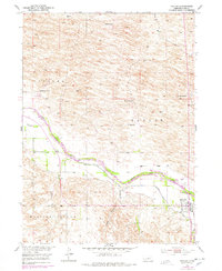
1952 Map of Taylor
USGS Topo · Published 1954About this map
The North Loup River valley dominates this mid-century Nebraska landscape, serving as the primary corridor for settlement and infrastructure. The town of Taylor is situated near the riverbanks, where the presence of the Taylor-Ord Canal and Taylor Dam illustrates the region's managed water systems. Significant family holdings and cattle operations are identified through named landmarks like Worm Ranch, Hawthorne Ranch, and McGraw Ranch, providing a clear record of local land ownership and rural residency in the early 1950s.
Find a feature on this map
18 named features on this map. Tap any name to fly to it.
Don’t see what you’re looking for? This feature index may not catch every label — zoom into the map to look around manually.
Map Details
Editions of this 1952 Taylor Map
2 editions found
Other maps of this area

1951 · Walworth
USGS Topo · 1:24,000

1952 · Sargent East
USGS Topo · 1:24,000

1952 · Taylor NW
USGS Topo · 1:24,000

1952 · Almeria NE
USGS Topo · 1:24,000

1952 · Sargent West
USGS Topo · 1:24,000

1952 · Taylor SE
USGS Topo · 1:24,000

1952 · Almeria
USGS Topo · 1:24,000

1952 · Taylor NE
USGS Topo · 1:24,000

1955 · Broken Bow
USGS Topo · 1:250,000

1956 · Broken Bow
USGS Topo · 1:250,000