
1885 Map of Taylor
USGS Topo · Published 1885About this map
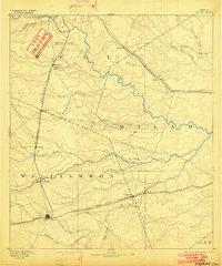
The railroad-driven expansion of Central Texas is prominently displayed in this 1885 survey, where several major lines converge to shape the early development of Williamson and Milam Counties. Taylor stands as a central hub at the junction of the International and Great Northern Railroad and the Missouri Pacific Railroad, anchoring a landscape defined by its fertile blackland prairie and meandering watercourses. To the north, the Gulf Colorado and Santa Fe Railroad cuts across the terrain, supporting settlements like Rogers and Buckholts.
Find a feature on this map
39 named features on this map. Tap any name to fly to it.
Don’t see what you’re looking for? This feature index may not catch every label — zoom into the map to look around manually.
Map Details
Editions of this 1885 Taylor Map
This is the sole edition of this map. No revisions or reprints were ever made.
Other maps of this area

1885 · Bastrop
USGS Topo · 1:125,000

1887 · Taylor
USGS Topo · 1:125,000

1892 · Temple
USGS Topo · 1:125,000

1893 · Georgetown
USGS Topo · 1:125,000

1893 · Bastrop
USGS Topo · 1:125,000

1894 · Gatesville
USGS Topo · 1:125,000
1894 · Taylor
USGS Topo · 1:125,000

1896 · Austin
USGS Topo · 1:125,000

1897 · Austin
USGS Topo · 1:125,000

1904 · Bastrop
USGS Topo · 1:125,000