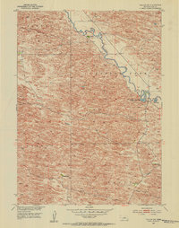
1952 Map of Taylor NW
USGS Topo · Published 1954About this map
The Calamus River meanders across this mid-century landscape of Loup County, revealing a sparse ranching economy defined by isolated homesteads and expansive range names. The presence of Upriver Ranch and Holmes Ranch highlights the dominance of large-scale landholdings in this part of the Nebraska Sandhills. Distinctive land divisions are marked by regional identifiers like Bloody, Little York, Strohl, and Taylor, which likely correspond to local townships or survey blocks. Along the river valley, unique water features such as Horseshoe Bend Lake and Mud Bayou provide critical breaks in the rolling terrain. Educational infrastructure of the era is preserved in the location of the Sebesta Sch, a rural schoolhouse that once served the children of the surrounding ranching families.
Find a feature on this map
12 named features on this map. Tap any name to fly to it.
Don’t see what you’re looking for? This feature index may not catch every label — zoom into the map to look around manually.
Map Details
Editions of this 1952 Taylor NW Map
4 editions found
Other maps of this area

1952 · Taylor NW
USGS Topo · 1:24,000

1952 · Almeria NE
USGS Topo · 1:24,000

1952 · Taylor SE
USGS Topo · 1:24,000

1952 · Almeria
USGS Topo · 1:24,000

1952 · Taylor
USGS Topo · 1:24,000

1952 · Taylor NE
USGS Topo · 1:24,000

1955 · Broken Bow
USGS Topo · 1:250,000

1955 · O'Neill
USGS Topo · 1:250,000

1956 · Broken Bow
USGS Topo · 1:250,000

1959 · O'Neill
USGS Topo · 1:250,000