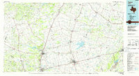
1985 Map of Taylor
USGS Topo · Published 1986About this map
The Lampasas Mountains and the rolling blackland prairies of Central Texas define this mid-1980s landscape, centered on the strategic rail hubs of Taylor and Hutto. The map highlights a complex hydrography where the San Gabriel River and Lampasas River systems converge, dominated by the footprint of Granger Lake. This era shows the transition of the region from its agrarian roots to a more connected corridor, with the Missouri Kansas Texas, Atchison Topeka and Santa Fe, and Missouri Pacific railroads facilitating the transport of cattle and crops across the Bell and Williamson county lines.
Find a feature on this map
118 named features on this map. Tap any name to fly to it.
Don’t see what you’re looking for? This feature index may not catch every label — zoom into the map to look around manually.
Map Details
Editions of this 1985 Taylor Map
2 editions found
Other maps of this area

1885 · Taylor
USGS Topo · 1:125,000

1885 · Bastrop
USGS Topo · 1:125,000

1887 · Taylor
USGS Topo · 1:125,000

1887 · Lampasas
USGS Topo · 1:125,000

1887 · Blanco
USGS Topo · 1:125,000

1887 · Burnet
USGS Topo · 1:125,000

1892 · Temple
USGS Topo · 1:125,000

1893 · Georgetown
USGS Topo · 1:125,000

1893 · Burnet
USGS Topo · 1:125,000

1893 · Bastrop
USGS Topo · 1:125,000