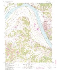
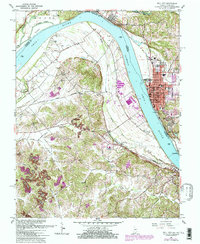
1961 Map of Tell City
USGS Topo · Published 1981About this map
Tell City and the neighboring river towns of Cannelton and Hawesville anchor this 1961 survey, documenting the industrial and residential development along the sharp bends of the Ohio River. The river serves as the primary corridor for commerce, flanked by the Southern and Louisville and Nashville railroads. While the riverfront is defined by manufacturing and municipal hubs like City Hall, the surrounding hills are marked by small rural communities and family landmarks. Genealogists will find numerous family burial grounds, including Thrasher Cem, Greathouse Cem, and Henderson Cem, alongside local spiritual centers such as St Marys Chapel and Hilldale Ch. The landscape south of the river shows active extraction at a Strip Mine, contrasting with the more settled riverbanks where Legion Field and the County Memorial Hospital serve the growing population.
Find a feature on this map
53 named features on this map. Tap any name to fly to it.
Don’t see what you’re looking for? This feature index may not catch every label — zoom into the map to look around manually.
Map Details
Editions of this 1961 Tell City Map
5 editions found
Other maps of this area

1900 · St Meinrad
USGS Topo · 1:62,500

1903 · St. Meinrad
USGS Topo · 1:62,500

1903 · Tell City
USGS Topo · 1:62,500

1934 · Cannelton
USGS Topo · 1:62,500

1949 · Cannelton
USGS Topo · 1:24,000

1953 · Cannelton
USGS Topo · 1:24,000

1953 · Lewisport
USGS Topo · 1:24,000

1953 · Cloverport
USGS Topo · 1:24,000

1953 · Tell City
USGS Topo · 1:24,000
1953 · Maceo
USGS Topo · 1:24,000