
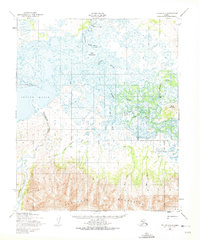
1950 Map of Teller A-1
USGS Topo · Published 1956About this map
Marys Igloo and the adjacent settlement of New Igloo stand as central points of activity on the banks of the winding Kuzitrin River in this mid-century survey of the Seward Peninsula. The landscape is defined by the dramatic transition from the tidal flats and braided waterways of the Imuruk Basin to the steep, rising peaks of the Kigluaik Mountains to the south. Further north, Davidsons Landing provides a point of arrival near the confluence of the Marys River and Davidson Slough. Transportation in this subarctic environment relies on seasonal routes, including a documented Tractor Trail and a Winter Trail that cross the lowlands, connecting the remote settlements and an Air Strip to the broader landscape of Marys Mountain and the interior.
Find a feature on this map
19 named features on this map. Tap any name to fly to it.
Don’t see what you’re looking for? This feature index may not catch every label — zoom into the map to look around manually.
Map Details
Editions of this 1950 Teller A-1 Map
2 editions found
Other maps of this area

1950 · Bendeleben A-6
USGS Topo · 1:63,360

1950 · Bendeleben B-6
USGS Topo · 1:63,360

1950 · Nome D-2
USGS Topo · 1:63,360

1950 · Nome
USGS Topo · 1:250,000

1950 · Teller
USGS Topo · 1:250,000

1950 · Bendeleben
USGS Topo · 1:250,000

1950 · Teller A-2
USGS Topo · 1:63,360

1950 · Solomon
USGS Topo · 1:250,000

1950 · Solomon D-6
USGS Topo · 1:63,360

1950 · Nome D-1
USGS Topo · 1:63,360