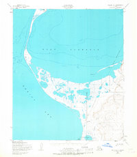
1950 Map of Teller A-4
USGS Topo · Published 1967About this map
Port Clarence dominates this coastal landscape, serving as a significant sheltered harbor separated from the Bering Sea by narrow sand spits. The interior terrain is characterized by complex hydrology, featuring a vast Tidal Flat and numerous small drainages such as Sourdough Creek, Bridget Creek, and Gold Standard. Human presence is represented by small clusters of dwellings, specifically 10 Cabins and 8 Cabins, reflecting the seasonal or subsistence-based settlement patterns of the Seward Peninsula during the mid-20th century.
Find a feature on this map
18 named features on this map. Tap any name to fly to it.
Don’t see what you’re looking for? This feature index may not catch every label — zoom into the map to look around manually.
Map Details
Editions of this 1950 Teller A-4 Map
2 editions found
Other maps of this area

1950 · Nome D-4
USGS Topo · 1:63,360

1950 · Nome
USGS Topo · 1:250,000

1950 · Teller
USGS Topo · 1:250,000

1950 · Nome D-3
USGS Topo · 1:63,360

1950 · Teller B-4
USGS Topo · 1:63,360

1950 · Teller A-3
USGS Topo · 1:63,360

1950 · Teller A-4
USGS Topo · 1:63,360

1950 · Teller B-3
USGS Topo · 1:63,360
1950 · Teller B-5
USGS Topo · 1:63,360

1951 · Nome
USGS Topo · 1:250,000