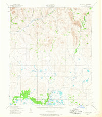
1950 Map of Teller B-1
USGS Topo · Published 1967About this map
Kaviruk River meanders through a landscape of braided drainages and high plateaus in this mid-century survey of the Seward Peninsula. The drainage patterns are defined by numerous named tributaries, including Louisville Creek, Kentucky Creek, and Johnston Creek, which flow through the upland terrain. The presence of a solitary Cabin in the southern lowlands, accessible only by a Tractor Trail, suggests the seasonal subsistence or mining activities characteristic of the region during the 1950s. A network of routes such as the Trail and various tractor paths provide the only overland connection across the tundra. The mapping of the Base Line across the northern section of the sheet illustrates the early efforts of the Bureau of Land Management to establish a grid over this unsurveyed territory. The topography, captured via photogrammetric methods from 1950 aerial photography, shows the intricate relief from the headwaters of Igloo Creek to the marshy flats near Hunter Creek.
Find a feature on this map
19 named features on this map. Tap any name to fly to it.
Don’t see what you’re looking for? This feature index may not catch every label — zoom into the map to look around manually.
Map Details
Editions of this 1950 Teller B-1 Map
2 editions found
Other maps of this area

1950 · Bendeleben A-6
USGS Topo · 1:63,360

1950 · Bendeleben B-6
USGS Topo · 1:63,360

1950 · Bendeleben C-6
USGS Topo · 1:63,360

1950 · Teller
USGS Topo · 1:250,000

1950 · Bendeleben
USGS Topo · 1:250,000

1950 · Teller A-2
USGS Topo · 1:63,360

1950 · Teller A-1
USGS Topo · 1:63,360

1950 · Teller B-2
USGS Topo · 1:63,360

1950 · Teller B-1
USGS Topo · 1:63,360

1950 · Teller C-2
USGS Topo · 1:63,360