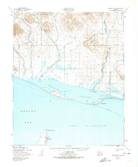
1950 Map of Teller B-4
USGS Topo · Published 1974About this map
Port Clarence serves as the focal point of this coastal survey, situated on a narrow spit of land at the southern edge of Brevig Lagoon. This mid-century landscape is defined by its seasonal transport routes, most notably the extensive Winter Trail that traverses the frozen expanses and coastal margins. To the north, the terrain rises sharply toward Black Mtn, with the Don River and California River carving through the tundra to meet the Bering Sea. The map reveals a specialized maritime and aviation infrastructure, indicated by a Light at Point Spencer and a nearby Landing Strip. These features suggest the area's importance for cold-weather navigation and logistical support during the post-war era, while the network of smaller waterways like Toser Creek and Constance Creek highlights the intricate drainage patterns of the Seward Peninsula.
Find a feature on this map
21 named features on this map. Tap any name to fly to it.
Don’t see what you’re looking for? This feature index may not catch every label — zoom into the map to look around manually.
Map Details
Editions of this 1950 Teller B-4 Map
2 editions found
Other maps of this area

1950 · Teller
USGS Topo · 1:250,000

1950 · Teller B-4
USGS Topo · 1:63,360

1950 · Teller C-3
USGS Topo · 1:63,360

1950 · Teller A-3
USGS Topo · 1:63,360

1950 · Teller C-4
USGS Topo · 1:63,360

1950 · Teller A-4
USGS Topo · 1:63,360

1950 · Teller B-3
USGS Topo · 1:63,360
1950 · Teller B-5
USGS Topo · 1:63,360

1950 · Teller C-5
USGS Topo · 1:63,360

1951 · Teller
USGS Topo · 1:250,000