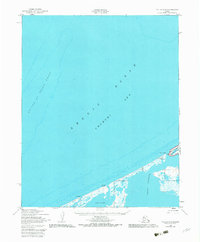
1950 Map of Teller D-6
USGS Topo · Published 1982About this map
The vast coastal intersection of the Arctic Ocean and the Chukchi Sea dominates this 1950s-era topographic survey. Along the Seward Peninsula shoreline, the shallow waters of Lopp Lagoon are separated from the open sea by a narrow barrier of land, where small seasonal settlements like Mitletukeruk and Mit-Le-Topik are established. This landscape is defined by its extreme northern geography, featuring navigational landmarks like the submerged Prince of Wales Shoal and coastal formations such as Sin-i-Rock and Ah-Gude-Le-Rock.
Find a feature on this map
11 named features on this map. Tap any name to fly to it.
Don’t see what you’re looking for? This feature index may not catch every label — zoom into the map to look around manually.
Map Details
Editions of this 1950 Teller D-6 Map
3 editions found
Other maps of this area

1950 · Teller
USGS Topo · 1:250,000

1950 · Shishmaref
USGS Topo · 1:250,000

1950 · Teller C-6
USGS Topo · 1:63,360
1950 · Teller C-7
USGS Topo · 1:63,360

1950 · Teller D-5
USGS Topo · 1:63,360
1950 · Teller D-6
USGS Topo · 1:63,360

1950 · Teller C-5
USGS Topo · 1:63,360

1951 · Shishmaref
USGS Topo · 1:250,000

1951 · Teller
USGS Topo · 1:250,000

1957 · Teller
USGS Topo · 1:250,000