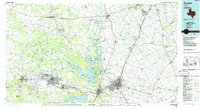
1985 Map of Temple
USGS Topo · Published 1985About this map
The Fort Hood Military Reservation dominates the western half of this Central Texas landscape, a massive footprint of mid-century defense infrastructure established over formerly rural ranch land. Adjacent to this military expanse, the Naval Industrial Reserve Ordinance Plant sits near McGregor, while the Gatesville State School for Boys is located at the edge of the Leon River valley. This 1980s data reflects a region defined by large-scale institutions and a dense network of transit, including the Missouri Kansas Texas Railroad and the Atchison Topeka and Santa Fe Railway converging on Temple. Outside the urban corridors, small agrarian communities like Westphalia, Zabcikville, and Ratibor maintain the legacy of European settlement patterns in the Brazos River basin. Notable terrain features include the Henson Mountains and numerous peaks like Stampede Mountain, which rise above the river bottomlands and the shores of Belton Lake.
Find a feature on this map
169 named features on this map. Tap any name to fly to it.
Don’t see what you’re looking for? This feature index may not catch every label — zoom into the map to look around manually.
Map Details
Editions of this 1985 Temple Map
2 editions found
Other maps of this area

1885 · Taylor
USGS Topo · 1:125,000

1887 · Taylor
USGS Topo · 1:125,000

1887 · Lampasas
USGS Topo · 1:125,000

1887 · Burnet
USGS Topo · 1:125,000

1888 · Hamilton
USGS Topo · 1:125,000

1888 · Meridian
USGS Topo · 1:125,000

1892 · Temple
USGS Topo · 1:125,000

1892 · Waco
USGS Topo · 1:125,000

1893 · Georgetown
USGS Topo · 1:125,000

1893 · Burnet
USGS Topo · 1:125,000