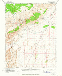
1953 Map of Temple Mtn
USGS Topo · Published 1964About this map
Temple Mtn serves as a prominent landmark in this mid-century survey of the San Rafael Swell, where industrial extraction and natural erosional wonders meet. The map reveals a cluster of tunnels and shafts near the mountain, reflecting the era's uranium prospecting and mining activity, often coordinated with the Atomic Energy Commission. To the south, the intricate topography of Goblin Valley begins to take shape alongside striking formations like Mollys Castle and Little Gilson Butte. The landscape is defined by the Sinbad and Reef regions, where water sources are scarce, marked primarily by scattered catchments such as Farnsworth Tanks and Mormon Tanks. A lone Landing Strip and various jeep trails provide the only modern access through the winding washes and canyons of the San Rafael Desert.
Find a feature on this map
35 named features on this map. Tap any name to fly to it.
Don’t see what you’re looking for? This feature index may not catch every label — zoom into the map to look around manually.
Map Details
Editions of this 1953 Temple Mtn Map
3 editions found
Other maps of this area

1885 · San Rafael
USGS Topo · 1:250,000

1952 · Wild Horse
USGS Topo · 1:62,500

1952 · San Rafael Knob
USGS Topo · 1:62,500

1953 · Stinking Spring Creek 2 SE
USGS Topo · 1:24,000

1953 · Tidwell 2 SW
USGS Topo · 1:24,000

1953 · Tidwell 3 NW
USGS Topo · 1:24,000

1953 · Temple Mtn
USGS Topo · 1:62,500

1954 · Stinking Springs Creek 4 SW
USGS Topo · 1:24,000

1954 · Stinking Spring Creek 1 SE
USGS Topo · 1:24,000

1954 · Stinking Spring Creek 3 SE
USGS Topo · 1:24,000