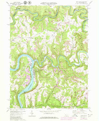
1969 Map of Templeton
USGS Topo · Published 1980About this map
The Allegheny River carves a deep horseshoe bend near Templeton and Reesedale, serving as a central artery for the region's industrial and natural activity during the late 1960s. This survey illustrates a landscape heavily shaped by extraction and infrastructure, notably featuring the Lock and Dam No 8 and the extensive State Game Lands No 287. The rugged topography is dissected by Mahoning Creek and Redbank Creek, with numerous Strip Mine symbols marking the ridges between small settlements like Kellersburg and Widnoon.
Find a feature on this map
40 named features on this map. Tap any name to fly to it.
Don’t see what you’re looking for? This feature index may not catch every label — zoom into the map to look around manually.
Map Details
Editions of this 1969 Templeton Map
4 editions found
Other maps of this area

1900 · Kittanning
USGS Topo · 1:62,500

1901 · Rural Valley
USGS Topo · 1:62,500

1902 · Kittanning
USGS Topo · 1:62,500

1903 · Rural Valley
USGS Topo · 1:62,500

1906 · Clarion
USGS Topo · 1:62,500

1907 · Clarion
USGS Topo · 1:62,500

1907 · Foxburg
USGS Topo · 1:62,500

1908 · Foxburg
USGS Topo · 1:62,500

1953 · Pittsburgh
USGS Topo · 1:250,000

1954 · Pittsburgh
USGS Topo · 1:250,000