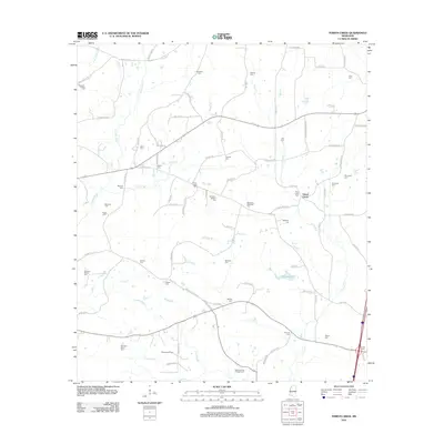
2012 Map of Terrys Creek
USGS Topo · Published 2012About this map
The Tickfaw River and its numerous tributaries, including Easley Br and Terrys Cr, define the drainage patterns of this rural Pike County landscape. This 2012 survey illustrates a region where family legacy is deeply rooted in the land, evidenced by the high density of small burial grounds such as Newman-Phillips Cem, Simpson-Raborn Cem, and McDaniel-McElveen Cem. The settlement at Terrys Creek serves as a central point in a network of country roads including Terrys Creek Rd and Old Mill Rd. Economic and recreational activity is noted in the southern portion of the quadrangle, where the Gillsburg Oil Field operates alongside the Osyka Springs Campground. Water features like Alford Lake and Ponchatoula Cr further characterize the terrain, providing a detailed look at the local geography of southern Mississippi.
Find a feature on this map
88 named features on this map. Tap any name to fly to it.
Don’t see what you’re looking for? This feature index may not catch every label — zoom into the map to look around manually.
Map Details
Editions of this 2012 Terrys Creek Map
This is the sole edition of this map. No revisions or reprints were ever made.
Other maps of this area

1940 · Spring Creek
USGS Topo · 1:31,680

1942 · Liverpool
USGS Topo · 1:31,680

1950 · Kentwood
USGS Topo · 1:31,680

1953 · Natchez
USGS Topo · 1:250,000

1954 · Baton Rouge
USGS Topo · 1:250,000

1956 · Natchez
USGS Topo · 1:250,000

1956 · Baton Rouge
USGS Topo · 1:250,000
1958 · Kentwood
USGS Topo · 1:62,500
1958 · Mount Hermon
USGS Topo · 1:62,500

1959 · Natchez
USGS Topo · 1:250,000