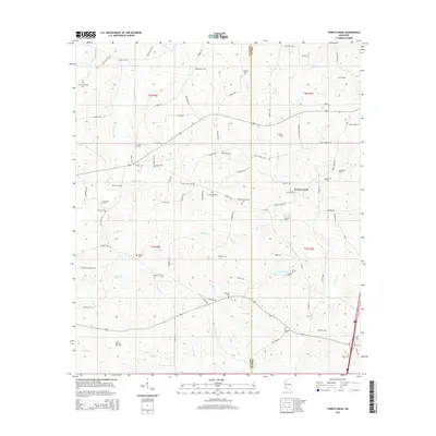
2015 Map of Terrys Creek
USGS Topo · Published 2015About this map
The Amite Co and Pike Co border divides this rural Mississippi landscape, where a dense network of family-named cemeteries provides a rich record of the area's ancestral heritage. The settlement of Terrys Creek serves as a central landmark, situated near the headwaters of Terrys Cr and Trinity Cr. This terrain is deeply etched by a complex drainage system including the Tickfaw River and its multiple branches, such as Easley Br and Breland Br, which likely shaped the placement of early homesteads and transport routes.
Find a feature on this map
86 named features on this map. Tap any name to fly to it.
Don’t see what you’re looking for? This feature index may not catch every label — zoom into the map to look around manually.
Map Details
Editions of this 2015 Terrys Creek Map
This is the sole edition of this map. No revisions or reprints were ever made.
Other maps of this area

1940 · Spring Creek
USGS Topo · 1:31,680

1942 · Liverpool
USGS Topo · 1:31,680

1950 · Kentwood
USGS Topo · 1:31,680

1953 · Natchez
USGS Topo · 1:250,000

1954 · Baton Rouge
USGS Topo · 1:250,000

1956 · Natchez
USGS Topo · 1:250,000

1956 · Baton Rouge
USGS Topo · 1:250,000
1958 · Kentwood
USGS Topo · 1:62,500
1958 · Mount Hermon
USGS Topo · 1:62,500

1959 · Natchez
USGS Topo · 1:250,000