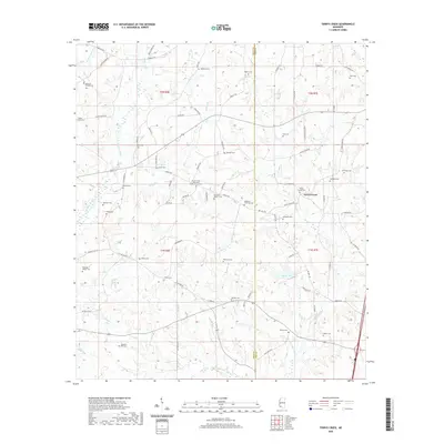
2020 Map of Terrys Creek
USGS Topo · Published 2020About this map
Terrys Creek sits at the heart of this landscape along the border of Amite and Pike Counties, where the drainage systems of the Tickfaw River and Terrys Creek define the local topography. This region is remarkably dense with family burial grounds, reflecting generations of deep-rooted settlement across the south Mississippi piney woods. Genealogists will find a significant concentration of historical markers, from the Terrys Creek Missionary Baptist Church Cem to smaller family plots like the Simpson Raborn Cem, Newman-Phillips Cem, and the Hampton Wall Cem. The area is interlaced with rural routes such as Hamp Lea Rd and Grange Hall Rd, which connect these small family enclaves. Water features like Alford Lake and numerous branches, including Easley Br and Friday Cr, underscore the creek-bottom character of the terrain during the early 21st century.
Find a feature on this map
84 named features on this map. Tap any name to fly to it.
Don’t see what you’re looking for? This feature index may not catch every label — zoom into the map to look around manually.
Map Details
Editions of this 2020 Terrys Creek Map
This is the sole edition of this map. No revisions or reprints were ever made.
Other maps of this area

1940 · Spring Creek
USGS Topo · 1:31,680

1942 · Liverpool
USGS Topo · 1:31,680

1950 · Kentwood
USGS Topo · 1:31,680

1953 · Natchez
USGS Topo · 1:250,000

1954 · Baton Rouge
USGS Topo · 1:250,000

1956 · Natchez
USGS Topo · 1:250,000

1956 · Baton Rouge
USGS Topo · 1:250,000
1958 · Kentwood
USGS Topo · 1:62,500
1958 · Mount Hermon
USGS Topo · 1:62,500

1959 · Natchez
USGS Topo · 1:250,000