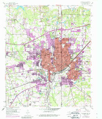
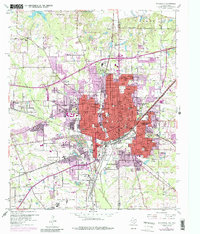
1954 Map of Texarkana
USGS Topo · Published 1987About this map
The Texarkana metropolitan area straddles the state line in the mid-1950s, revealing a dense urban core supported by a massive network of competing rail lines. The industrial and transportation identity of the border city is clear, with the Texas and Pacific, St Louis Southwestern, and Missouri Pacific railroads converging near the city center. Significant local infrastructure includes the Federal Correctional Institution to the south and Bringle Lake to the north, while the residential expansion into Wake Village and Nash is documented with mid-century updates. The map provides excellent detail for genealogical research, naming numerous segregated or neighborhood-focused schools such as Booker T Washington High Sch, Carver Sch, and Dunbar High Sch, alongside numerous community landmarks like Red Springs Ch and the State Line Cem.
Find a feature on this map
67 named features on this map. Tap any name to fly to it.
Don’t see what you’re looking for? This feature index may not catch every label — zoom into the map to look around manually.
Map Details
Editions of this 1954 Texarkana Map
6 editions found

Other maps of this area

1909 · Texarkana
USGS Topo · 1:62,500

1950 · Ogden
USGS Topo · 1:24,000

1950 · Barkman
USGS Topo · 1:24,000

1951 · Ogden
USGS Topo · 1:24,000

1951 · Barkman
USGS Topo · 1:24,000

1951 · Homan
USGS Topo · 1:24,000

1952 · Mandeville
USGS Topo · 1:24,000

1952 · Fouke
USGS Topo · 1:24,000

1953 · Texarkana
USGS Topo · 1:250,000

1953 · El Dorado
USGS Topo · 1:250,000