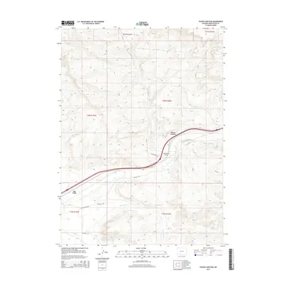
2015 Map of Thayer Junction
USGS Topo · Published 2015About this map
Thayer Junction and Salt Wells sit within the high desert landscape of Sweetwater County, where the infrastructure of modern transit meets the faint tracks of the westward migration. The map documents a critical corridor where the historic Overland Trl route parallels the modern Interstate and rail lines, following the natural passage provided by Bitter Cr. This convergence of transportation eras highlights the enduring importance of this rugged path through the Great Divide Basin. To the south, Black Butte Cr and Salt Wells Cr drain through the arid terrain, while local routes like Salt Wells Ranch Rd and Salt Wells Rd provide access to the expansive rangelands. The topographical relief is most pronounced at Horsethief Canyon, a geographic landmark just south of the junction that further emphasizes the corridor's physical constraints.
Find a feature on this map
18 named features on this map. Tap any name to fly to it.
Don’t see what you’re looking for? This feature index may not catch every label — zoom into the map to look around manually.
Map Details
Editions of this 2015 Thayer Junction Map
This is the sole edition of this map. No revisions or reprints were ever made.
Other maps of this area

1908 · Rock Springs
USGS Topo · 1:62,500

1910 · Rock Springs
USGS Topo · 1:62,500

1954 · Rock Springs
USGS Topo · 1:250,000

1958 · Rock Springs
USGS Topo · 1:250,000

1958 · Boars Tusk
USGS Topo · 1:62,500

1958 · Superior
USGS Topo · 1:62,500

1962 · Rock Springs
USGS Topo · 1:250,000

1968 · North Baxter
USGS Topo · 1:24,000

1968 · Point Of Rocks SW
USGS Topo · 1:24,000

1968 · Point Of Rocks
USGS Topo · 1:24,000