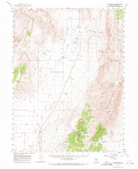
1961 Map of The Cedars
USGS Topo · Published 1971About this map
Reese River flows through the central basin of this Great Basin landscape, flanked by the dramatic elevations of the Fish Creek Mountains to the west and the Shoshone Range to the east. At the start of the 1960s, this area of Lander County remained a territory of sparse ranching and significant topographical landmarks, such as the evocative Valley of the Moon and the high summit of Elephant Head. Human presence is marked by isolated outposts like Fish Creek Ranch and Smith Flat, while the legacy of earlier transportation is visible in the Old Railroad Grade cutting across the valley floor. Geothermal activity is indicated by Hot Springs near the river, and the terrain is dotted with evidence of exploration including a Mine and various Prospect locations, reflecting the region's long-standing connection to mineral interests and high-desert pastoralism.
Find a feature on this map
32 named features on this map. Tap any name to fly to it.
Don’t see what you’re looking for? This feature index may not catch every label — zoom into the map to look around manually.
Map Details
Editions of this 1961 The Cedars Map
3 editions found

Other maps of this area

1926 · Roberts Mountains
USGS Topo · 1:250,000

1929 · Roberts Mountains
USGS Topo · 1:250,000

1932 · Sonoma Range
USGS Topo · 1:250,000

1939 · Sonoma Range
USGS Topo · 1:250,000

1949 · Mt. Lewis
USGS Topo · 1:62,500

1950 · Mt. Lewis
USGS Topo · 1:62,500

1955 · Millett
USGS Topo · 1:250,000

1955 · Winnemucca
USGS Topo · 1:250,000

1956 · Hall Creek
USGS Topo · 1:62,500

1958 · Winnemucca
USGS Topo · 1:250,000