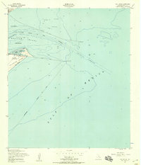
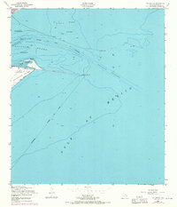
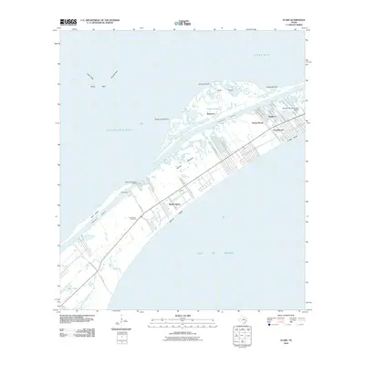
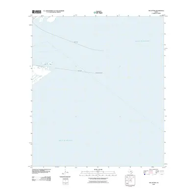
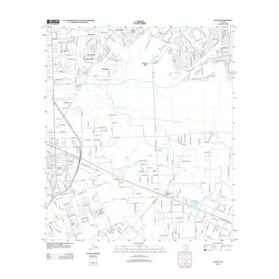
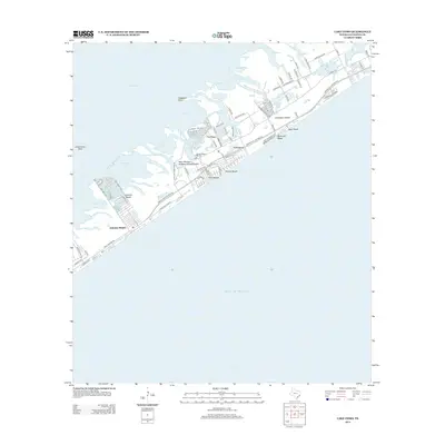
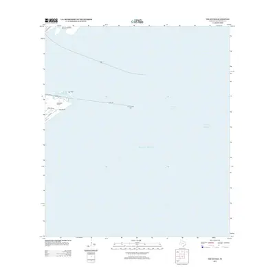
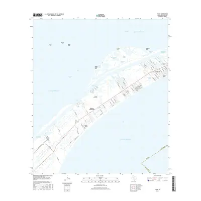
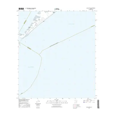
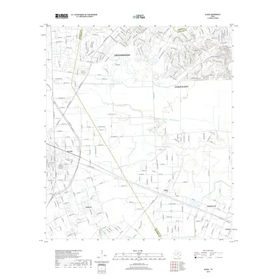
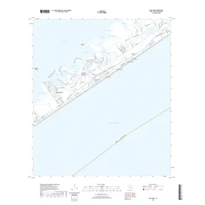
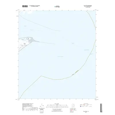
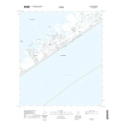
1954 Map of The Jetties
USGS Topo · Published 1958About this map
The North Jetty and South Jetty define the narrow gateway to the Texas coast in the mid-1950s, reaching miles into the Gulf of Mexico. This map details the critical maritime engineering required to maintain the Inner Bar Channel and Outer Bar Channel for navigation into the protected waters of Bolivar Roads. On the tip of Galveston Island, the site of Old Fort San Jacinto stands near the expansive East Beach and the shifting sands of Big Reef. Opposite the channel, the Bolivar Peninsula tapers into a series of tidal flats and sandbars. This survey documents the specific bathymetry and infrastructure of the era, including the Galveston Jetty Light and the established Galveston City Limits as they extended across the water.
Find a feature on this map
19 named features on this map. Tap any name to fly to it.
Don’t see what you’re looking for? This feature index may not catch every label — zoom into the map to look around manually.
Map Details
Editions of this 1954 The Jetties Map
3 editions found
Historical Maps of Galveston Through Time
96 maps found

1929 Algoa
Galveston County, TX

1929 Karankawa Lake
Galveston County, TX

1929 Virginia Point
Galveston County, TX

1931 Flake
Galveston County, TX

1931 Lake Como
Galveston County, TX

1932 Algoa
Galveston County, TX

1932 Bolivar Point
Galveston County, TX

1932 Virginia Point
Galveston County, TX

1933 Bolivar Point
Galveston County, TX

1933 Caplen
Galveston County, TX

1933 Carancahua Lake
Galveston County, TX

1933 Flake
Galveston County, TX

1933 Lake Como
Galveston County, TX

1933 San Luis Pass
Galveston County, TX

1933 The Jetties
Galveston County, TX

1943 Caplen
Galveston County, TX

1943 Carancahua Lake
Galveston County, TX

1943 Flake
Galveston County, TX

1943 Lake Como
Galveston County, TX

1943 Port Bolivar
Galveston County, TX

1943 San Luis Pass
Galveston County, TX

1943 The Jetties
Galveston County, TX

1943 Virginia Point
Galveston County, TX

1954 Caplen
Galveston County, TX

1954 Flake
Galveston County, TX

1954 Lake Como
Galveston County, TX

1954 Port Bolivar
Galveston County, TX

1954 The Jetties
Galveston County, TX

1954 Virginia Point
Galveston County, TX

1956 Algoa
Galveston County, TX

1963 San Luis Pass
Galveston County, TX

1963 Sea Isle
Galveston County, TX

1994 Caplen
Galveston County, TX

1994 Flake
Galveston County, TX

1994 Lake Como
Galveston County, TX

1994 Port Bolivar
Galveston County, TX

1994 The Jetties
Galveston County, TX

1994 Virginia Point
Galveston County, TX

1995 Virginia Point
Galveston County, TX
2010 Algoa
Galveston County, TX
2010 Caplen
Galveston County, TX
2010 Flake
Galveston County, TX
2010 Galveston OE S
Galveston County, TX
2010 Lake Como
Galveston County, TX
2010 Port Bolivar
Galveston County, TX
2010 San Luis Pass
Galveston County, TX
2010 Sea Isle
Galveston County, TX
2010 The Jetties
Galveston County, TX
2010 Virginia Point
Galveston County, TX
2013 Algoa
Galveston County, TX
2013 Caplen
Galveston County, TX
2013 Flake
Galveston County, TX
2013 Galveston OE S
Galveston County, TX
2013 Lake Como
Galveston County, TX
2013 Port Bolivar
Galveston County, TX
2013 San Luis Pass
Galveston County, TX
2013 Sea Isle
Galveston County, TX
2013 The Jetties
Galveston County, TX
2013 Virginia Point
Galveston County, TX
2016 Algoa
Galveston County, TX
2016 Caplen
Galveston County, TX
2016 Flake
Galveston County, TX
2016 Galveston OE S
Galveston County, TX
2016 Lake Como
Galveston County, TX
2016 Port Bolivar
Galveston County, TX
2016 San Luis Pass
Galveston County, TX
2016 Sea Isle
Galveston County, TX
2016 The Jetties
Galveston County, TX
2016 Virginia Point
Galveston County, TX
2019 Algoa
Galveston County, TX
2019 Caplen
Galveston County, TX
2019 Flake
Galveston County, TX
2019 Galveston OE S
Galveston County, TX
2019 Lake Como
Galveston County, TX
2019 Port Bolivar
Galveston County, TX
2019 San Luis Pass
Galveston County, TX
2019 Sea Isle
Galveston County, TX
2019 The Jetties
Galveston County, TX
2019 Virginia Point
Galveston County, TX

2022 Algoa
Galveston County, TX
2022 Caplen
Galveston County, TX
2022 Flake
Galveston County, TX

2022 Galveston OE S
Galveston County, TX
2022 Lake Como
Galveston County, TX

2022 Port Bolivar
Galveston County, TX
2022 San Luis Pass
Galveston County, TX
2022 Sea Isle
Galveston County, TX
2022 The Jetties
Galveston County, TX

2022 Virginia Point
Galveston County, TX

2025 Caplen
Galveston County, TX

2025 Flake
Galveston County, TX

2025 Galveston OE S
Galveston County, TX

2025 Lake Como
Galveston County, TX

2025 San Luis Pass
Galveston County, TX

2025 Sea Isle
Galveston County, TX

2025 The Jetties
Galveston County, TX