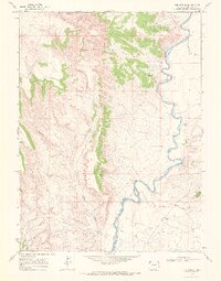
1969 Map of The Nipple
USGS Topo · Published 1972About this map
The Little Snake River meanders across this high-desert landscape in Moffat County, defining the eastern half of the quadrangle with its tight loops and sandbars. As mapped in the late 1960s, the area reflects a sparsely populated ranching environment where water sources and topographic landmarks dictate the movement of people and livestock. The Nipple and Red Wash Butte serve as primary navigational points in a terrain deeply dissected by drainages like Spence Gulch and Nipple Gulch. Cultural footprints are limited to the Nipple Rim Ranch and essential river crossings designated simply as Ford, illustrating the remote character of this northwestern Colorado region before modern developments changed local access.
Find a feature on this map
11 named features on this map. Tap any name to fly to it.
Don’t see what you’re looking for? This feature index may not catch every label — zoom into the map to look around manually.
Map Details
Editions of this 1969 The Nipple Map
2 editions found
Other maps of this area

1954 · Vernal
USGS Topo · 1:250,000

1958 · Vernal
USGS Topo · 1:250,000

1958 · Maybell
USGS Topo · 1:62,500

1960 · Vernal
USGS Topo · 1:250,000

1960 · Lone Mountain
USGS Topo · 1:62,500

1969 · Reservoir Draw
USGS Topo · 1:24,000
1969 · The Nipple SE
USGS Topo · 1:24,000

1969 · The Nipple
USGS Topo · 1:24,000
1969 · The Nipple NE
USGS Topo · 1:24,000

1969 · Powder Wash
USGS Topo · 1:24,000