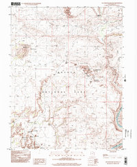
1996 Map of The Windows Section
USGS Topo · Published 2002About this map
Arches National Park reveals its complex geological architecture in this late 20th-century survey of the high desert. Concentrated within The Windows Section, iconic formations like Double Arch, North Window, and South Window stand as central landmarks near the sprawling expanse of Willow Flats. The map illustrates a landscape defined by vertical relief, from the towering heights of the Courthouse Towers and The Organ to the winding course of the Colorado River at the southeastern boundary. Narrow 4WD tracks provide the primary means of navigating between these landmarks, connecting the Garden of Eden with more remote features like the Eye of the Whale and the monolithic Tower of Babel. This document records the intricate network of washes, such as Salt Valley Wash and Winter Camp Wash, that have shaped the sandstone over millennia.
Find a feature on this map
39 named features on this map. Tap any name to fly to it.
Don’t see what you’re looking for? This feature index may not catch every label — zoom into the map to look around manually.
Map Details
Editions of this 1996 The Windows Section Map
This is the sole edition of this map. No revisions or reprints were ever made.
Other maps of this area

1885 · La Sal
USGS Topo · 1:250,000

1952 · Moab 4 NW
USGS Topo · 1:24,000

1952 · Moab 4 SW
USGS Topo · 1:24,000

1954 · Mt. Waas 3 NW
USGS Topo · 1:24,000

1954 · Mt. Waas 3 SW
USGS Topo · 1:24,000

1954 · Castle Valley
USGS Topo · 1:62,500

1956 · Moab
USGS Topo · 1:250,000

1958 · Thompson
USGS Topo · 1:62,500

1958 · Cisco
USGS Topo · 1:62,500

1959 · Moab
USGS Topo · 1:250,000