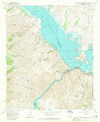
1964 Map of Theodore Roosevelt Dam
USGS Topo · Published 1965About this map
The massive Theodore Roosevelt Dam stands at the confluence of the Salt River and Tonto Creek, anchoring a landscape shaped by early 20th-century water engineering. By the mid-1960s, the resulting reservoir, Theodore Roosevelt Lake, reached up toward Henderson Mesa, its fluctuating shoreline creating features like Rabbit Island and Haystack Island. The settlement of Roosevelt serves as a small hub for the surrounding Tonto National Forest, while the winding Apache Trail provides access to the steep terrain of Two Bar Ridge and the Tonto National Monument in the southeast. This survey captures a moment when the region's ranching and mining past, evidenced by Mills and Buckhorn Spring, transitioned into a destination for recreation at sites like the Burnt Corral Campground. The map clearly delineates the Maricopa and Gila County boundary as it bisects the northern reaches of Apache Lake.
Find a feature on this map
53 named features on this map. Tap any name to fly to it.
Don’t see what you’re looking for? This feature index may not catch every label — zoom into the map to look around manually.
Map Details
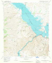
Editions of this 1964 Theodore Roosevelt Dam Map
2 editions found
Other maps of this area

1907 · Roosevelt
USGS Topo · 1:125,000

1909 · Four Peaks
USGS Topo · 1:125,000

1912 · Roosevelt
USGS Topo · 1:125,000

1954 · Mesa
USGS Topo · 1:250,000

1957 · Mesa
USGS Topo · 1:250,000

1958 · Mesa
USGS Topo · 1:250,000

1960 · Mesa
USGS Topo · 1:250,000

1964 · Mesa
USGS Topo · 1:250,000
1964 · Armer Mountain
USGS Topo · 1:24,000
1964 · Greenback Creek
USGS Topo · 1:24,000