
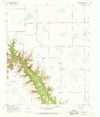
1956 Map of Thomas Ranch
USGS Topo · Published 1957About this map
Thomas Ranch and several other family holdings occupy the high plains above the dramatic incision of Palo Duro Canyon in this mid-century survey of Randall County. The landscape is defined by the sharp contrast between the level, playa-dotted surface of the Llano Estacado and the deep, eroded drainage systems that feed into the canyon floor. Named features like Windmill Draw and Dugout Draw point to the practicalities of ranching in this arid environment, where water access was managed through features like Lake Az and numerous springs along the canyon walls. The network of family-named sites, including Stevens Ranch and Upshaw Ranch, illustrates a period of established cattle operations before modern suburban expansion began to alter the character of the region south of Amarillo. The topography reveals intricate geological detailing within Deep Canyon and Forked Draw, providing a clear record of the area's natural drainage before significant modern alteration.
Find a feature on this map
28 named features on this map. Tap any name to fly to it.
Don’t see what you’re looking for? This feature index may not catch every label — zoom into the map to look around manually.
Map Details
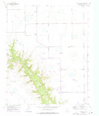
Editions of this 1956 Thomas Ranch Map
3 editions found
Other maps of this area

1954 · Amarillo
USGS Topo · 1:250,000

1954 · Plainview
USGS Topo · 1:250,000

1956 · Fortress Cliff
USGS Topo · 1:24,000

1956 · Amarillo East
USGS Topo · 1:24,000

1956 · Washburn
USGS Topo · 1:24,000

1956 · Pullman
USGS Topo · 1:24,000

1958 · Amarillo
USGS Topo · 1:250,000

1958 · Plainview
USGS Topo · 1:250,000

1960 · Canyon
USGS Topo · 1:62,500

1960 · Fairview
USGS Topo · 1:24,000