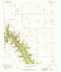
1956 Map of Thomas Ranch
USGS Topo · Published 1968About this map
Palo Duro Canyon dominates this 1950s survey of the Texas Panhandle, revealing the dramatic transition from the flat High Plains to the deeply eroded breaks of the Red River. The map documents a landscape defined by large-scale ranching operations, including Thomas Ranch, Stevens Ranch, and Sorelle Ranch, which sit atop the relatively level tableland. The terrain drops sharply into a network of rugged drainage features such as Thomas Draw, Chalk Hollow, and Dugout Draw, all feeding into the primary canyon floor. Within the depths of the canyon, essential water sources like Blue Spring and Deep Spring are marked alongside the Park Trail, indicating early recreational access and land management. The presence of an Oil Well and several windmill-dependent draws highlights the dual economic reliance on ranching and natural resources in this part of Randall County. Significant revisions from 1967, shown in purple, reflect subtle changes in the local infrastructure and land use over the decade following the original fieldwork.
Find a feature on this map
29 named features on this map. Tap any name to fly to it.
Don’t see what you’re looking for? This feature index may not catch every label — zoom into the map to look around manually.
Map Details
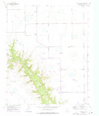
Editions of this 1956 Thomas Ranch Map
3 editions found
Other maps of this area

1954 · Amarillo
USGS Topo · 1:250,000

1954 · Plainview
USGS Topo · 1:250,000

1956 · Fortress Cliff
USGS Topo · 1:24,000

1956 · Amarillo East
USGS Topo · 1:24,000

1956 · Washburn
USGS Topo · 1:24,000

1956 · Thomas Ranch
USGS Topo · 1:24,000

1956 · Pullman
USGS Topo · 1:24,000

1958 · Amarillo
USGS Topo · 1:250,000

1958 · Plainview
USGS Topo · 1:250,000

1960 · Canyon
USGS Topo · 1:62,500