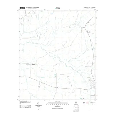
2011 Map of Thomaston West
USGS Topo · Published 2011About this map
Chickasaw Bogue meanders through this portion of Marengo County, defining the drainage patterns of a landscape dotted with long-established cemeteries and small rural settlements. This 2011 topographic survey documents the intersection of local history and modern infrastructure, from the small community of Half Chance to the Linden Municipal Airport in the southwest. A high density of burial sites, including Tabernacle Cemetery, Saint Mathews Cemetery, and Little Flanders Field Cemetery, suggests deep ancestral roots in this agricultural region. The eastern edge is anchored by the town of Thomaston, while the Camp Thomaston State Prison Camp and Mitchell Dam illustrate the more institutional and industrial uses of the land. Throughout the quadrangle, minor watercourses like Sandy Branch and Little Dry Creek feed into larger arteries, reflecting the area's natural hydrology alongside a network of county roads named for local landmarks.
Find a feature on this map
53 named features on this map. Tap any name to fly to it.
Don’t see what you’re looking for? This feature index may not catch every label — zoom into the map to look around manually.
Map Details
Editions of this 2011 Thomaston West Map
This is the sole edition of this map. No revisions or reprints were ever made.
Other maps of this area

1953 · Montgomery
USGS Topo · 1:250,000

1956 · Montgomery
USGS Topo · 1:250,000

1957 · Montgomery
USGS Topo · 1:250,000

1968 · Thomaston East
USGS Topo · 1:24,000

1968 · Uniontown West
USGS Topo · 1:24,000

1968 · Thomaston West
USGS Topo · 1:24,000

1968 · Gallion
USGS Topo · 1:24,000

1970 · Old Spring Hill
USGS Topo · 1:24,000

1970 · Linden
USGS Topo · 1:24,000
1978 · Flatwood
USGS Topo · 1:24,000