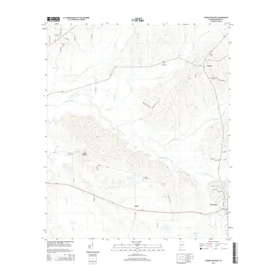
2014 Map of Thomaston West
USGS Topo · Published 2014About this map
The town of Thomaston and the crossroads of Half Chance anchor this Marengo County landscape, defined by the winding course of Chickasaw Bogue and its numerous tributaries. Settled within a complex network of creeks including Sandy Br and Dry Creek, the area shows a distinct pattern of rural development focused around family and community landmarks. Genealogists will find a wealth of burial sites across the township, ranging from Saint Mathews Cem and Saint Peter Cem to the uniquely named Little Flanders Field Cem and Cades Chapel Cem. The transition from the more developed streets of Thomaston—including 2nd Ave and Coats Ave—to the open reaches near Hugo and Dayton illustrates the historical agricultural and timber-driven character of the Alabama Black Belt. Water features like Mitchell Lake and Whitley Lake further distinguish the low-lying terrain near the creek beds.
Find a feature on this map
57 named features on this map. Tap any name to fly to it.
Don’t see what you’re looking for? This feature index may not catch every label — zoom into the map to look around manually.
Map Details
Editions of this 2014 Thomaston West Map
This is the sole edition of this map. No revisions or reprints were ever made.
Other maps of this area

1953 · Montgomery
USGS Topo · 1:250,000

1956 · Montgomery
USGS Topo · 1:250,000

1957 · Montgomery
USGS Topo · 1:250,000

1968 · Thomaston East
USGS Topo · 1:24,000

1968 · Uniontown West
USGS Topo · 1:24,000

1968 · Thomaston West
USGS Topo · 1:24,000

1968 · Gallion
USGS Topo · 1:24,000

1970 · Old Spring Hill
USGS Topo · 1:24,000

1970 · Linden
USGS Topo · 1:24,000
1978 · Flatwood
USGS Topo · 1:24,000