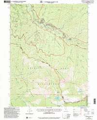
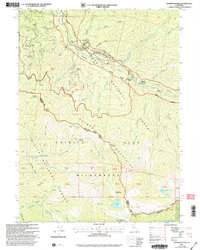
2001 Map of Thompson Peak
USGS Topo · Published 2004About this map
Petersburg Station and the riverside flat of Summerville anchor the northern reaches of this mountain landscape along the South Fork Salmon River. This 2001 revision highlights a terrain defined by historical extractive sites and early ranching footprints, where mines and prospects are scattered across steep drainage basins like Yellow Jacket Basin and Black Gulch. The boundary between Siskiyou and Trinity counties cuts through the heart of the Trinity Alps Wilderness, a protected expanse where high-altitude water bodies like Grizzly Lake and Sapphire Lake sit beneath the shadows of Thompson Peak and Caesar Peak. Evidence of local history and isolated settlement is preserved in labels for Schoolhouse Flat, Moliter Cabin, and Bobs Farm, alongside small burial sites marked simply as Cem and Grave near the river’s edge.
Find a feature on this map
52 named features on this map. Tap any name to fly to it.
Don’t see what you’re looking for? This feature index may not catch every label — zoom into the map to look around manually.
Map Details
Editions of this 2001 Thompson Peak Map
2 editions found
Other maps of this area

1886 · Shasta
USGS Topo · 1:250,000

1890 · Red Bluff
USGS Topo · 1:250,000

1894 · Red Bluff
USGS Topo · 1:250,000

1894 · Shasta
USGS Topo · 1:250,000

1909 · Big Bar
USGS Topo · 1:96,000

1913 · Weaverville
USGS Topo · 1:125,000

1915 · Big Bar and Vicinity
USGS Topo · 1:250,000

1923 · Sawyers Bar
USGS Topo · 1:125,000

1931 · Etna
USGS Topo · 1:96,000

1934 · Etna
USGS Topo · 1:125,000