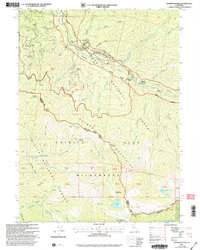
2001 Map of Thompson Peak
USGS Topo · Published 2004About this map
The South Fork Salmon River and Salmon River carve through a landscape of high alpine basins and early mountain homesteads on the border of Siskiyou and Trinity counties. This 2001 revision illustrates the transition from riverfront settlements like Summerville and Petersburg Station to the interior wilds of the Trinity Alps Wilderness. Evidence of 19th-century activity persists in labels for a mine, numerous prospects, and the solitary Prospect Grave.
Find a feature on this map
59 named features on this map. Tap any name to fly to it.
Don’t see what you’re looking for? This feature index may not catch every label — zoom into the map to look around manually.
Map Details
Editions of this 2001 Thompson Peak Map
2 editions found
Other maps of this area

1886 · Shasta
USGS Topo · 1:250,000

1890 · Red Bluff
USGS Topo · 1:250,000

1894 · Red Bluff
USGS Topo · 1:250,000

1894 · Shasta
USGS Topo · 1:250,000

1909 · Big Bar
USGS Topo · 1:96,000

1913 · Weaverville
USGS Topo · 1:125,000

1915 · Big Bar and Vicinity
USGS Topo · 1:250,000

1923 · Sawyers Bar
USGS Topo · 1:125,000

1931 · Etna
USGS Topo · 1:96,000

1934 · Etna
USGS Topo · 1:125,000