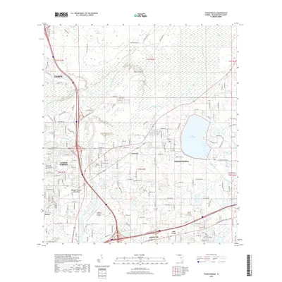
2018 Map of Thonotosassa
USGS Topo · Published 2018About this map
Lake Thonotosassa dominates the eastern half of this Hillsborough County landscape, serving as a focal point for the surrounding community of Thonotosassa. The terrain reflects the transition from suburban expansion near Tampa and Temple Terrace to the preserved wetlands of the Hillsborough River basin. Modern infrastructure is evident in the dense network of major thoroughfares, including the convergence of I-75 and I-4, which frame the southern and western edges of the quadrangle.
Find a feature on this map
158 named features on this map. Tap any name to fly to it.
Don’t see what you’re looking for? This feature index may not catch every label — zoom into the map to look around manually.
Map Details
Editions of this 2018 Thonotosassa Map
This is the sole edition of this map. No revisions or reprints were ever made.
Other maps of this area

1921 · Tampa
USGS Topo · 1:62,500

1943 · Thonotosassa
USGS Topo · 1:24,000

1943 · Lutz
USGS Topo · 1:24,000

1944 · Sulphur Springs
USGS Topo · 1:31,680

1944 · Mango
USGS Topo · 1:31,680

1944 · Tampa
USGS Topo · 1:31,680

1944 · Wesley Chapel
USGS Topo · 1:31,680

1944 · Lutz
USGS Topo · 1:31,680

1944 · Thonotosassa
USGS Topo · 1:31,680

1944 · Antioch
USGS Topo · 1:31,680