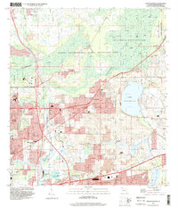
1995 Map of Thonotosassa
USGS Topo · Published 2000About this map
Lake Thonotosassa dominates the eastern landscape of this Hillsborough County survey, illustrating the transition from natural wetlands to suburban development in the mid-1990s. The northern reaches are characterized by the preserved wildlands of the Hillsborough River State Park and the expansive Lower Hillsborough Flood Detention Area, while the southwest corner shows the city's growth in Temple Terrace. Small communities like Clarkwild and Thonotosassa are mapped alongside rural landmarks like Sanders Chapel and Marshall Ch. The infrastructure of the era is clearly defined by the Seaboard Coast Line railroad and the Tampa City Bypass canal, which cuts through Harney Flats. This map captures a moment when citrus-era settlements and family-named churches still stood in contrast to the advancing infrastructure of the Tampa corridor.
Find a feature on this map
53 named features on this map. Tap any name to fly to it.
Don’t see what you’re looking for? This feature index may not catch every label — zoom into the map to look around manually.
Map Details
Editions of this 1995 Thonotosassa Map
This is the sole edition of this map. No revisions or reprints were ever made.
Other maps of this area

1921 · Tampa
USGS Topo · 1:62,500

1943 · Thonotosassa
USGS Topo · 1:24,000

1943 · Lutz
USGS Topo · 1:24,000

1944 · Sulphur Springs
USGS Topo · 1:31,680

1944 · Mango
USGS Topo · 1:31,680

1944 · Tampa
USGS Topo · 1:31,680

1944 · Wesley Chapel
USGS Topo · 1:31,680

1944 · Lutz
USGS Topo · 1:31,680

1944 · Thonotosassa
USGS Topo · 1:31,680

1944 · Antioch
USGS Topo · 1:31,680