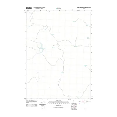
2010 Map of Thorn Creek Reservoir
USGS Topo · Published 2010About this map
Thorn Creek Reservoir and its associated Thorn Creek Dam serve as the primary focus of this high-desert water management landscape. This 2010 survey reveals an intricate network of small reservoirs and springs designed to capture and hold water across the arid terrain. Features such as Divide Reservoir, Snake Reservoir, and Crows Nest Reservoir are scattered throughout the quadrangle, illustrating the importance of livestock and agricultural water storage in the region. The map identifies specific locales like Pole Corral and Twin Oaks, which suggest the historic and ongoing grazing utility of the land. Waterways like Portuguese Creek and Preacher Creek provide a framework for the drainage patterns that feed into the larger reservoirs, while named terrain features like Crows Nest rise above the basin floor.
Find a feature on this map
19 named features on this map. Tap any name to fly to it.
Don’t see what you’re looking for? This feature index may not catch every label — zoom into the map to look around manually.
Map Details
Editions of this 2010 Thorn Creek Reservoir Map
This is the sole edition of this map. No revisions or reprints were ever made.
Other maps of this area

1955 · Hailey
USGS Topo · 1:250,000

1957 · Thorn Creek SE
USGS Topo · 1:24,000

1957 · Thorn Creek SW
USGS Topo · 1:24,000

1957 · Thorn Creek
USGS Topo · 1:62,500

1957 · Bellevue
USGS Topo · 1:62,500

1957 · Blaine
USGS Topo · 1:62,500

1959 · Hailey
USGS Topo · 1:250,000

1962 · Hailey
USGS Topo · 1:250,000

1979 · Summit Reservoir
USGS Topo · 1:24,000
1979 · Mammoth Cave
USGS Topo · 1:24,000