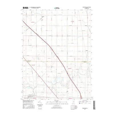
2016 Map of Thorntown
USGS Topo · Published 2016About this map
Thorntown sits at the southern edge of this landscape, positioned where Sugar Creek and Spring Cr converge. The area is defined by a dense network of county roads that navigate a fertile agricultural plain, crossing numerous tributaries like Goldsberry Cr, Brush Cr, and Little Potato Cr. Small rural settlements such as Manson, Antioch, and Reagan serve as local anchors, reflecting the dispersed nature of Central Indiana's farming communities. For genealogists, the map is particularly valuable for its documentation of local burial grounds, including Manson Cem, Brush Creek Cem, Gipson Cem, and Bethel Hill Cem. The surveyor's level detail also reveals early drainage infrastructure, with named channels like Eagle Ditch and Sims Rogers Ditch illustrating the long-term management of the watershed to support the surrounding acreage.
Find a feature on this map
99 named features on this map. Tap any name to fly to it.
Don’t see what you’re looking for? This feature index may not catch every label — zoom into the map to look around manually.
Map Details
Editions of this 2016 Thorntown Map
This is the sole edition of this map. No revisions or reprints were ever made.
Other maps of this area

1953 · Lebanon
USGS Topo · 1:24,000

1953 · Danville
USGS Topo · 1:250,000

1955 · Danville
USGS Topo · 1:250,000

1956 · Danville
USGS Topo · 1:250,000

1961 · Michigantown
USGS Topo · 1:24,000

1961 · Mulberry
USGS Topo · 1:24,000

1961 · Mechanicsburg
USGS Topo · 1:24,000

1961 · Frankfort
USGS Topo · 1:24,000
1961 · Hazelrigg
USGS Topo · 1:24,000
1961 · Shannondale
USGS Topo · 1:24,000